Mackay Country
Dùthaich Mhic Aoidh
An area in North-West Scotland of natural unspoiled beauty, rich in heritage & history
Bettyhill
Situated at the head of Strathnaver Valley, Bettyhill was one of 64 communities that populated the area before the Sutherland clearances in the early 19th Century and was one of the few to remain after them. Bettyhill is both welcoming and interesting.
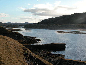
The River Naver flows into the sea here from Strathnaver. Invernaver and Torisdale Bay to the west of Bettyhill comprise an important nature reserve. Between the mouths of the Rivers Borgie and Naver on the west side of Bettyhill is one of the most important botanical sites in Scotland The Invernaver National Nature Reserve, designated in 1960 but is now an SSSI.
This area has a wide variety of lime and acid loving species such as crowberry, mountain avens, moss campion and bearberry with notable dwarf shrubs Because of the severe exposure, uncommon mountain plants can be found growing almost at sea level. The raised beach contains archaeological sites

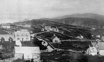
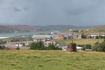
Bettyhill, the Gaelic name is An Bloran Odor – The grey place has a population of about 492. Once known as Bettyhill of Farr and founded originally as a fishing and agricultural centre. Bettyhill is a fairly recent creation. To day this is a crofting community set among rocky green hills, straggles along the side of a narrow tidal estuary, and down the coast to two splendid beaches, which in the past had the functions of a small port, market and resort above Torrisdale Bay. To north is Farr Bay, where precious stones can be found. The village of Bettyhill makes a good stop. Bettyhill is a small and dispersed settlement on the North Coast between the villages of Tongue to the west and Melvich to the east. Bettyhill sits on the northern coastline 9 miles (15 km) south west of Strathy Point.
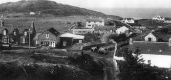
The village grew as a settlement in the early 19th Century when many of the tenants of the Duke of Sutherland were evicted from their inland straths to crofting plots on the coasts. The original village is beyond the sands of Farr Bay. In the area that was Farr there is now a straggling crofting settlement set in about moorland lying a mile east of Bettyhill. Most of the dramatic changes in Mackay Country occurred at the time of the clearances and Bettyhill was no different. The valley of Strathnaver runs for fifteen miles south from Bettyhill and was once heavily populated. From 1807 the Sutherland estate systematically cleared the land of its inhabitants. In 1814 the village of Rossal in Strathnaver was cleared. Elizabeth, Countess of Sutherland, had an alternative village built near the coast on the east side of the mouth of the River Naver and she named the new village after herself as Bettyhill.Bettyhill today has three distinct parts. The modern housing and the Bettyhill Hotel, found on the main road as it ascends east above the River Naver, determine the centre. Bettyhill Hotel started in 1819, and has grown steadily. Its location is superb, giving magnificent views to the North West over Torrisdale Bay. The centre of the village takes a nucleated pattern built around the school and Post Office with many outlining croft houses.


East in a sheltered basin are the older parts of the village. The St Columba’s Parish Church of Farr, now the Strathnaver Museum. Farr Church was built in 1774 and, at the time could accommodate 750 people. By 1882, clearance, emigration and splits in the church meant that the upper galleries could be removed. It was converted into a museum in the 1970s. The excellent museum tells the story of Clan Mackay and of the 19th Century clearances and is full of locally donated bits and pieces, and includes panels by local schoolchildren telling the story of the Strathnaver Clearances.
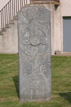
Outside museum is Farr Stone, an early eighth century Christian Celtic stone. This possibly marks the grave of some important political or religious person although local legends attach many mysterious to the stone. Close by is the Tourist Information Centre. The Ice house at Bettyhill is the remains of the once active Salmon netting station that operated until recently. The rich salmon fishing in the River Naver has been exploited for centuries
A Sweep net fishing station operated here and at various periods the icehouse and canning factory were in use to preserve fish for the sale in distant markets. In the early days of the village this formed an important fishing station. Little remains, and even the name, Navermouth, have all but disappeared.
To the north is the rock framed sandy beach of Farr Bay and, to the west and beyond the River Naver, the still more stunning expanse of sand making up Torrisdale Bay. In the mouth of the River Naver and opposite a wide expanse of rock-backed dunes is the neglected pier.
West of Bettyhill a loop road leads out to the crofting district of Skerray while inland at Borgie On the A838 towards tongue is Borgie Forrest nature trail. the extensive forestry plantations mark one of the forestry commissions original plantings in 1920. Some of the tallest trees in Sutherland can be found here. South of Bettyhill the B571 follows the River Naver down through Strathnaver. Hear can be seen the ruins of pre clearance villages with an interpretive trail at Rosal one of the old settlements. Beyond are the ruins of Grummore Broch.

The area of Strathnaver, which at one time covered a large part of north and west Sutherland, from Melvich to Cape Wrath, was all Mackay Country. The Clan has a very rich and varied history boasting several Clan Societies throughout the world. These societies and other clan members have contributed most of the exhibits and information on show in this room. There is some Pictish stones and a 3800-year-old, early Bronze Age beaker found in Strathnaver which was found in a burial kist close to the River Naver, the river valley south of the village, whose numerous prehistoric sites are mapped on an excellent pamphlet sold at the entrance desk. The Strathnaver area abounds with archaeological sites. The name Naver reflects the strong Norse influences which Sutherland has experienced in the past.