
Mackay Country
Dùthaich Mhic Aoidh
An area in North-West Scotland of natural unspoiled beauty, rich in heritage & history
GATEWAYS


Mackay Country is a defined area but the boundaries to this could be disputed depending on the period in time that identification was made. For the purposes of today’s identification we have tried to follow the mountain lines and watersheds that would have been natural boundaries and landmarks in the past. This is not always definitive especially as roads and modern transport have become the ways of travelling as opposed to mountain passes and water ways. The routes into Mackay country today are the road boundaries we suggest would have been on the areas likely to have been best for defence and observation. The rearrangement of parish, local government and county lines have all helped to colour the actual. We therefore have included the areas that have assisted and indicated an interest in ensuring that they are incorporated into Mackay Country today.
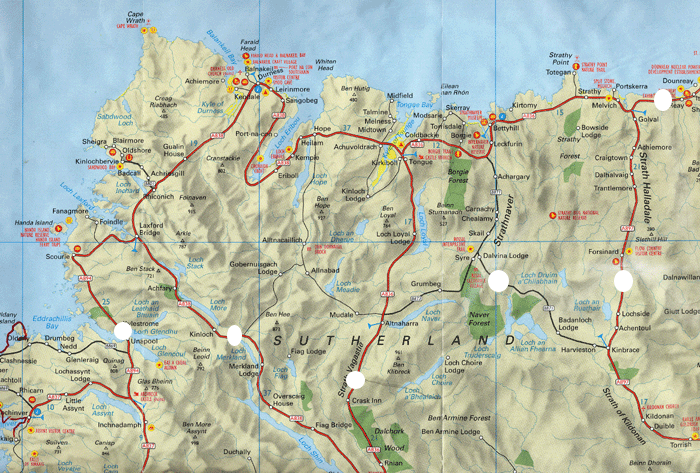
A
B
C
D
E
F
-
Sign A Kylesku NC 225 339 North end of Car park on north side of Kylesku Bridge.
-
Sign B A 836 Merkland on left side Of the road facing north NC 396 258
-
Sign C A836 Dalvina Lodge, Crask, road south of Vagastie Bridge 1 mile southwest of Syre/
-
Sign D NC 706 412. B871 Junction Off Loch Palm.
-
Sign E Forsinard, NC 884 406 One mile south of Forsinard raihvay station on A897 adjacent to the start of forestry plantation beside the RSPB cairn.
-
Sign F Caithness / Sutherland Border NC 919 645 on the A836 on the left facing west.


In this early part of the twenty first century when new roads and methods of travel have evolved since the lands were fought over and claimed as Mackay Lands we have erected gateway markers that indicate the conceptual objective of the Mackay Country. They are not installed to declare borders or boundaries but for convenience and general appreciative value of the extent of the ancient lands. Mountains passes and obsolete tracks, river courses and fertile lands with the ability to provide shelter, food and defence were the important positions that were fought over. The roads we use today are new. The gateway markers are to ease the perception and welcome those inward bound to the Mackay Country.
On May the 8th 2005 Lord Thurso agreed to unveil the gateway marker for the reidentification of Mackay Country at the Sutherland Caithness border. Six signs were carved in Caithness slab as depicted and the roadway entrances to Mackay Country from Kylesku, Kinloch south of Achfary, north of the Crask in Strath Vassigate, Dalvina, Forsinard and the county border.
After about a year of organising and consultation the first Mackay Country gateway sign maker was unveiled at the Sutherland Caithness border slightly east of the ancient border of Dumolsten when the split stane stands. The last time that there was such a gathering of Mackay at this border was probably about 1746 when they gathered to keep the Jaccobites out of this strongly protestant land.
We erected these around 2003 and the design was based on a creation by Celia Wallis.
The sign incorporates one of the decorative panels of the Farr Stone. The birds are young doves and symbolise friendship while the knot work lacings are particular to the Pictish. We chose the design as the Farr Stone is synonymous with North Sutherland and neutral with no relevance to any particular grouping. Mackay Country Trust and the identification of Mackay Country today is not regarded or commemorating the clan. We are about all the historical times and the people that have lived and live and work in the area. The clan era is only one part of this - a very relevant and important part and allows a distinctiveness to the locality identity to be forged. The gateway signs were designed to be sympathetic to the environmentmanufatured from natural materials.
In 2010/2011 some of those original gateway markers had to be replaced due to flawed stone. The new ones are guaranteed to outlast all of us. This was achieved through financial help from Commun na Gaidhlig and a generous donation from Edward Mackay.

