Mackay Country
Dùthaich Mhic Aoidh
An area in North-West Scotland of natural unspoiled beauty, rich in heritage & history
The Rough Quarter
From Scourie the A894 joins the A836 from Achfary and turns north to Rhiconich.

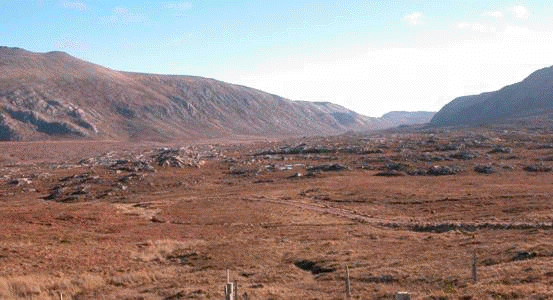
The road has reached just south of Rhiconich and passed through what has become known as the Ceathramh Garbh or “Rough Quarter” a bare barren, open windswept part of the country where there is more water than land with nothing higher than five hundred feet. About twenty square miles with at best half a dozen people. It lies between Loch Inchard to the north and Loch Laxford to the south with two sea lochs penetrating into the interior, Loch Dughaill and Loch a’Chadh Fi. The largest freshwater loch, Loch Crocach, is about one mile long and about three quarters of a mile wide lying in the centre. All around this area are boulders on hilltops left by receding ice at the end of the ice age. Folklore declare that they we put there by giants during games of skittles.
The road to Skerricha is about a mile further on. This road continues for about half a mile. A track from here leads to John Ridgways Adventure School. This was set up in the 1960’s and offers outdoor survival courses. John Ridgeway has accomplished may exploration exploits. Just prior to reaching Rhiconich on the A838 there is a track to Ardmore. This goes two miles to Portlevorchy, which overlooks Loch a a’Chadh with John Ridgawys adventure school opposite. There is no road from Portlevorchy to Ardmore.
On the south side of Rhiconich a road signposted to Achlyness leads along the side of Loch Inchard turning into a track at to Achlyness but continuing on to Rhivichie. This is a beautiful road with stunning views over Loch Inchard to the townships of Kinlochbervie. It is when the traveller visits this kind of locality that they are reminded of the spectacular beauty and ruggedness of the area. Views from the main roads can be wonderful but in the main do not expose the localities of outstanding wonder concealed in the many less accessible hamlets.
NORTH FROM RICHOINICH this is for the most part single-track road, there are small stretches of double track. From Rhiconich and Loch Inchard, the road heads inland through the remote and rocky terrain that makes up so much of this region.
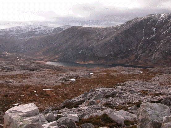
On to Durness the direction taken is north east cutting across the northern end of Foinaven in a wide valley with the road climbing to Gualin and views over Strath Dionard passing Fionaven (908) and Cranstackie (800). The road ascends towards Fionaven passing a winding twisting passage with lochans and rivers until the road climbs up towards the Guilin with mysterious inviting views into Strath Dionard.
At Gualin House a track runs into Strath Dionard, this passes along the side of Foinaven and reaches Loch Dionard. From around this point tracks can be followed to Loch Stack, Strath Beag, Glengolly and Strathmore. The interior of this land is “ancient highways” for walking around the land. The image perceived is one of a land of great scale and the possibility of reality of stories from the Hobbit and Lord of the Rings, backed by the mountains of Fionaven, Cranstackie, Ben Spionnaidh, Meall Meadhonach and Beinn Ceannabeinne and is spectacular.
Gualin Lodge is situated in this remote and beautiful country. Gualin House was built in the early 1880’s as a hotel by the Duke of Sutherland and then became a shooting Lodge. It means shoulder in Gaelic
The landscape is both breathtaking and dramatic and Gualin Estate offers extensive salmon fishing. The lodge, which enjoys open panoramic views up Strath Dionard, offers very comfortable accommodation for up to 10 guests on a self-catering basis. There is in addition a cottage that provides further accommodation for 2/3 and can be rented separately. Gualin Estate owns 6 miles of double bank fishing on the River Dionard, which is divided into six, two rod beats that rotate on a daily basis, including Loch Dionard, a wonderfully atmospheric place.
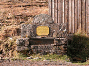
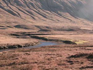
From the top of Gualin the roads winds and drops to Lawson’s Well at Carbreck. Under the shadow of Farrmheall on the west side of the road. It consists of an iron trough with a plaque and the inscription reads: ‘1883 As a mark of gratitude and respect to the inhabitants of Durness and Eddrachillis for their hospitality while projecting this road this inscription is placed over this well by their humble servant Peter Lawson surveyor’. Peter Lawson, a road surveyor, had the inscription placed close to the road he had been working on in the early 1830s. It may be because springs and wells are always flowing with fresh water that they are sometimes used as memorials.A walking track leads up Strath Dionard between the slopes of Cranstackie and Fionaven to Loch Dionard. From here further long distance paths continue to Glen golly, Starthmore, to Strath Beag and the end of Loch Eriboll and round the northern slopes of Creagan Meall Horn and down to Loch Stack. This is very wild but beautiful country The road passes the lonely cottage of Carbrek sitting at the side of the road. Rhigoltar the isolated shepherds’ cottage tucked under Ben Spionnaidh is about a mile and a half from the road. As the road descends the drive follows the course of the River Dionard, whose source is in the mountainous region in the south of Loch Eriboll. It drains the northern slopes of Creagan Meall Horn before entering Loch Dionard under the eastern slopes of Fionaven. At Grudgie, were this river and the River Grudie, which drains the northern slopes of Creag Riabhach, Farrmheall and Ghias Bheinn meet a small bridge accesses the shepherds cottage.
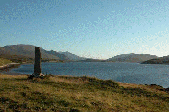
The road continues north and drops to the wide floor at the head of the Kyle of Durness and this can an amazing and ever-changing scene before the road finds its way along to Keoldale and the green fertile area of Durness on the northwest corner of the mainland. With a full tide the mass and water expanse is dominating the foreground but when the water empties from the Kyle and leaves large sand bars and areas of rivers and channels the scene is dramatically changed. With the varying light this vision is a special one to be savoured. One and a half miles south of Durness, where the road meets the shore of the Kyle of Durness is the road end to Keoldale and the ferry to Cape Wrath. The earth works of an Iron Age fort and numerous cairns can be found at Keoldale. The standing stone, erected as millennium project by the Durness Youth Club, is a recent addition close to the Iron Age fort site.