Mackay Country
Dùthaich Mhic Aoidh
An area in North-West Scotland of natural unspoiled beauty, rich in heritage & history
Loch Eriboll
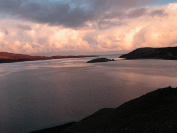
The name comes from the Norse “Eyrr-bol”, or “Farm on a beach”. Loch Eriboll is derived from the Norse meaning “home on a gravely beach.” Eyrar-bol ” Sandbank steading.” Bol- a farm, and Eyrr – a beach. Loch Eriboll , Hoan Fjord, is a lengthy and deep sea loch about sixteen kilometres long with a south – west direction and varying from one point five to six point five kilometres in breadth. On the east, it is bounded at the entrance by the clear and elevated rocks of Whiten Head. The waters are of a depth varying from fifteen to sixty fathoms. It is set in panoramic mountain hinterland dominated by Ben Hope. The east side is green with native lime rich fields, the west a rocky barren coast. The total length of the coastline is over thirty eight kilometres with a wide variety of shore types; bedrock, boulders, shingle, gravel, sand and mud.
The main input of fresh water is from Loch Hope situated near the seaward end and by comparison, Strath Beag at the inner end of the loch has a relatively small fresh water catchment area. Tidal streams are weak with only slight acceleration locally around the islands. Exposure to wave action ranges from the open coast at the entrance that is exposed to the north, to shelter in the inner reaches. The innermost parts of the loch have a considerable fetch to the north-east, and experience occasional wave action.


Approximately ten kilometres of coastline extending along the east side of the loch is included in a geological Site of Special Scientific Interest. The boundaries extend downwards to mean low water of spring tides. Loch Eriboll is the most northerly deep water sea loch in the British Isles and contains a wide range of sublittoral habitats and communities. Particularly rich animal communities are found on the vertical and steep bedrock near the entrance to the loch.
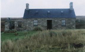
Past the house and souterrain site at Fouhlin the road (going east) follows the Eriboll coast to Whale’s Corner, named because a large whale was washed ashore here, and Kempie Bay. The loch has increasing numbers of Fish farms and associated sea food farming enterprises and the dwellings are occupied by workers for these. Some are small scale locally owned and operated and some are more commercial supplying local employment. The Estate of Eriboll and Eriboll Farm occupies most of the coastal land on the east shore of Loch Eriboll. The small church of Eriboll stands on the eastern side of the Loch.

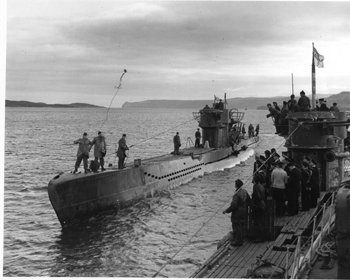
This loch has been used as a naval anchorage for much of the 20th century. Loch Eriboll was the site of the surrender of the German U-boat fleet in May 1945. Between the 10th and 20th May, over thirty U-boats came into Loch Eriboll.
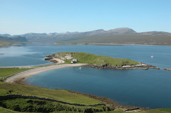
Loch Eriboll’s most intriguing feature is Ard Neakie. The crescent promontory of Ard Neakie pushes out to the middle from the eastern shore. It is connected to the mainland by a narrow split with two identically curving sandy beaches. Ard Neakie was once the site of a limestone quarry and limestone kilns. Both these features are still visible from the road. The lime was used in the 19th century as a neutralising agent when reclaiming peaty soils for cultivation Prior to this industry, Ard Neakie was one of the centres for a local kelp industry. the ferry house built in 1831 still stands. Ard Neakie is notable for the four large lime kilns built in 1870. The Reay estate produced large amounts of lime here and on the nearby island of Eilean Choraidh.
Alan Mackay who still lives and works locally had family that lived and worked at Heilam Ferry {Ardneakie} from 1885 to 1893 as boat builders and ferry operator. During the time the ferry was run by his family and there was a shop at Ardneakie.
The ferry continued to operate until the mid-1940s. Originally the ferry ran from Port na Con to Eriboll Farm.
Heilam Inn is the house on Ardneakie and ceased to be an inn around the 1850s. The inn was eventually refused a license to sell alcohol because of over indulgence by lime kiln workers, and there was also a sailor stabbed to death outside the house, whether this had any bearing on the loss of the license is unknown The liquor store still stands today. There are written articles about an ammunition store but there was never ammunition stored in the lime kilns but a mine did explode during WWII on the north bay of the peninsular.

The island in the mouth of Loch Eriboll, Eilean Hoan is leased by the RSPB and has been managed as a nature reserve since 1975. Ruins of homesteads are obvious but it was last occupied in the early 1800s. It was known as Howga in 1570 and Haga in 1601. As the name indicates it was the burial place of the Norsemen and probably used by their Gaelic successors.
When ships anchored in Loch Eriboll in the 1920s and 1930s some crew members would climb the hill to the west of the loch and leave their ship’s name written in stone letters about two metres high in a patch one by two metres. The best viewing point to see the names is at the first large lay-by beyond Port-na-con XE “Port-na-con” road end, at the disused quarry, travelling east and looking directly up the hill with a pair of binoculars, once identified can be distinguished. The stones are becoming embedded in the heather and slowly sinking. A walk to the ship’s names that include the Valiant, Swift, Whirlwind, Union, Unga, Lucretia, Johanna, (a Dutch minesweeper) and H43, the only submarine on the hillside, are within reach. A remarkable memorial that has lain largely unnoticed. Repeated attempts have failed to preserve the names. They include appeals to the Ministry of Defence; the War Grave’s Commission and the Queen.
The most prominent is the HOOD and it is the Hood’s tragic history that makes the hillside such a poignant spot. In 1994 the children of the primary school walked up the hillside and painted the stones of the HMS Hood XE “HMS Hood” and H43 to be visible from the roadside. The Hood was destroyed on May 23rd 1941 with the loss of 1418 lives, all the crew except for three. The German warship Bismarck off Greenland sank it in 1941. The Mighty Hood as she was known was the single biggest British naval loss in World War 11. When the war started, she was the largest warship in commission in the world. For the whole intra war period from her completion in 1920, HMS Hood had stood as a symbol of Britain’s supremacy as a sea power.

Just at Hope there is walking access to Whiten Head and Freisgill. There is no road or defined track but this remote area can be accessed by careful walking along the cliffs. The rocks here are greyish in colour giving the name Whiten Head or An Ceann Geal to the headland at the eastern entrance to Loch Eriboll. There are caves under the cliffs around Whiten Head where the Atlantic. Grey Seals breed the only known breeding place on the mainland. The caves are only accessible by boat. An exploration of this wild rocky coastline, with views out to the Orkney Islands and several saltwater lochs is spectacular.