
Mackay Country
Dùthaich Mhic Aoidh
An area in North-West Scotland of natural unspoiled beauty, rich in heritage & history
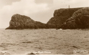
Cape Wrath


Eighteen kilometres from Durness Village is Cape Wrath.
In approximately 1795, a proposed improvement to navigation would be contributed if a lighthouse were erected at Cape Wrath. Some shipwrecks had happened in the previous ten years off the coast of Durness and it was considered the bearings of the rocks ought to be accurately ascertained. Built in 1828 by Robert Stevenson at a cost of fourteen thousand pounds, the buildings are extensive and spacious surrounded by a high wall.
The white tower is twenty meters high with eighty one steps to the top. The tower is built of hand dressed stone and the rest of the building is constructed of large blocks of granite quarried from Clash Carnoch. The lighthouse tower and dwelling houses are listed buildings of Architectural and Historic Interest.
The land between the village and the lighthouse is known as the Parph, two hundred and seven square kilometres of moorland.
The first road in the district, built in 1828 by the lighthouse commission, was constructed across the Parph (58` 37.5` N. Latitude; 50` 00.0`W. Latitude) to Britain’s most north westerly point.

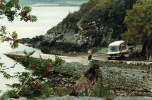
The Cape Wrath lighthouse stands over one hundred and twenty one meters high above mean sea level on spectacular cliffs facing the stormy Atlantic Ocean. To reach this point there is the choice of either a passenger ferry across the Kyle of Durness followed by a minibus ride of nearly eighteen kilometres on a narrow rough winding road through wild moorland, a twenty five mile walk up the coast from an approach at Sandwood Bay, landing by sea or by helicopter.
The Cape Wrath road is rough but has some magnificent views. From the bus, several interesting landmarks can be seen. Lying at the side of the road at Achiemore is a tin roof from the old Side School This was used last in 1947. The Royal Marines constructed the wooden bridge at Daill in 1980. Before the bridge was built the bus would frequently stall in the ford and the passengers used to get out and push. At Inshore there is a house owned by the MOD. The yellow and black huts are sentry posts manned during times when the naval range is active. The road ends at the lighthouse where there is an average of gales on thirty eight days of the year. The word Wrath is a corruption of the Norse word ‘Hvarf’ meaning turning point. Looking out to sea from the point are two low rocks, Am Bodach – The Old Man and A’Chailleach- The Old Woman. Looking east to Clo Mor at two hundred and seventy four metres is the highest cliff on mainland Britain.


From May to September the Cape Wrath ferry and Mini bus services carry passengers from Keoldale to the lighthouse. Two mini buses are transported over the Kyle of Durness on a purpose built raft towed by the smallest ferry operation in the land. Until recently the raft was a home constructed barge type vessel made from oil drums and palates.
The frequency of the service is dependent on the state of the tide and weather conditions. Sometimes about two hours either side of low tide the service can stop altogether. There is a channel on the Cape Wrath side, so sometimes a smaller boat is used to ferry passengers across the channel and they have to walk over the sand back to Keoldale. Walkers heading to the lighthouse, or over to Sandwood Bay and back via Kinlochbervie , cyclists and visitors, young and old take the mini bus ride there and back. The winter service is considerably scaled down with no transport on the Cape side except Balnakeil Farm and MoD. There are holiday houses and the Mountain Bothy Association has a bothy at Kervaig and Strathan. For more details on Cape Wrath and the excursion visit http://www.capewrath.org.uk

“Cape Wrath is one of the last untouched wilderness areas in Britain Between the Kyle of Durness to the lighthouse on the tip of the Cape, where there was once a small community, there is now just rough terrain populated by deer and sea birds.”
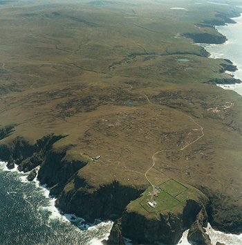


Around Cape Wrath is a military firing range, generally out of bounds to the public when exercises are occurring. A walk from the point where Garvie Island is nearly within touching distance from the cliff edge back towards Kearvaig is rewarding beyond description. Looking from the point at Cleit Dhubh at a closer perspective the island is bare rock and small

To the east of the lighthouse, above the bay of Kearvaig, are the highest sea cliffs in mainland Britain, the Clo Mor Cliffs. They have a drop of 281m (nearly 1000 feet).


Cape Wrath and Cape Cornwall, at completely the other end of the UK, are the only two Capes in Britain. Wrath is probably a very bad English approximation of the Gaelic word for Cape Wrath, which is Am Parbh (pronounced “am parve”). In the Lewis dialect of Gaelic, it is Carbh not Parbh. Parbh is one of the few Gaelic place names to take the definite article, Am. Ultimately the Gaelic derives from the Old Norse for Cape in the sense of “Headland used as a turning point”, and so Cape Wrath actually means ‘Cape Cape’.
Cape Wrath - A guide to the most north-westerly point of the UK mainland, detailing the excursion, lighthouse, Ozone Cafe, bus/ferry times, maps, and history.

Nearby are the ruins of a coastguard station built by Lloyds of London to keep a eye over their insured ships and the job the lighthouse was doing making sure no unnecessary insurance claims would come their way.
